FLIR ® (FLIRScan) Approved Business Contractors

ACCESSiFLY IS THE RECOGNIZED INDUSTRY LEADER
Our groundbreaking work in traditional "On Foot" as well as "Remotely Piloted Aircraft/Drone" inspections has been featured at FLIR ® 's 2020 Annual Inframation Conference as a "Keynote" (click HERE to view the Presentation made by Company President, Mr. Chris Gorczynski) as well as being subject of a major Case Study conducted by ESRI (click here to read the industry changing publication). The professional relationships we have forged with ESRI & FLIR ® ensure we remain up front and we hold their products in the highest regard and urge all visitors to consider those above any other.
Why settle for anything outside extraordinary.
LEVEL 3 MASTER INFRARED THERMOGRAPHERS
ACCESSiFLY are proud to carry the honour of being an officially approved, registered, licensed, and certified, FLIR ® & FLIRScan Business Contracting Service. Operating with FLIR ® 's approval across Canada, our Level 3 Master Infrared Thermographers hold the highest level of Certification obtainable in Infrared Imaging, Analysis and Reporting across all Domains (Aerial Thermal Infrared (RPAS), Building Investigations, Commercial Building Sciences, Advanced Electrical Inspections, Roof Inspections as well as Optical Gas Imaging). As such we guarantee our work to be of an unmatched standard.
PATENT & "RECOGNIZED" REVOLUTIONARY IP & APPROACH
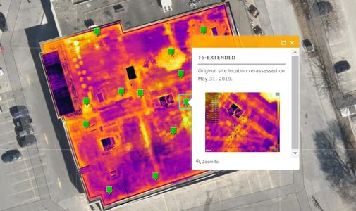
We have an exclusive Patent on the IP Protocol for "Executing and Georeferencing Aerial Thermal Infrared Imagery and Integrated GIS Applications" with Innovation, Science and Economic Development Canada (#1166978). As well as owning and developing the Patent on the Thermal Infrared Targets themselves which we use to deliver a 100% authentic 2D & 3D Radiometric Infrared Orthomosaic product using FLIR ® Hardware & ESRI Drone2Map exclusively.
INTEGRATED DELIVERABLES
We are able to deploy and perform an inspection of this nature in a manner that is absolutely unobtrusive in 1/4 the time it takes any other organization to conduct an inspection either "by foot" or with a Remotely Piloted Aircraft ("Drone"). Most importantly, we are able to integrate these Thermal Infrared Deliverables using this targeting method with BIM, LiDAR & Terrestrial Laser Scanning inside a GIS with a "Referenced Control Point" (RTK/GNSS) yielding an accuracy no other can match. We also offer these services at a fraction of the cost our competitors do for inferior products.
SPECIALIZED AERIAL THERMAL INFRARED IMAGING (THERMOGRAPHY)
FASTER. SAFER. MORE RELIABLE.
FASTER. SAFER. MORE RELIABLE.
FASTER. SAFER. MORE RELIABLE.

Remotely Piloted Aircraft Systems (Drone Inspections) equipped with FLIR Thermal Infrared Imaging can quickly and safely locate potential problem spots ("Prevention Analysis") and/or inefficiencies ("Deficiency Assessment"). Thermography is extraordinarily useful in Upstream Systems, Midstream Infrastructure, and Downstream Facilities. High resolution Infrared & NIR (Near Infrared/Red Edge) images & video of Vegetation (NDVI) is critical in modern Precision Agriculture, an area of deep and special interest of ours.
Industrial Plants, Platforms, Power Lines, Substations, Towers, Flare Stacks, Pipelines, Wind Turbines, Solar Fields, Rooftops and general Building Sciences Infrastructure Modelling (BIM) can be collected quickly. Gone are the days and/or need for extraordinarily risky Scaffolds, wasted workhours and revenue, and costly third-party tenders to visualize hard-to-reach locations. Coupled with our “Terrestrial” (“on-foot”) Infrared Thermal Imaging services, an ACCESSiFLY ITC Certified Thermographer can legally and accurately diagnose your facility and/or work in collaboration towards NDST (Non-destructive Testing) and research outcomes.
KEY BENEFITS
FASTER. SAFER. MORE RELIABLE.
FASTER. SAFER. MORE RELIABLE.
Key Benefits of Remotely Piloted Aircraft Systems (Drone Inspections): include:
- Greatly enhanced leak detection ability
- Safer and faster inspections by minimizing the use of cranes and scaffolding
- No need for "down turning" a plant or "close booting" a facility to ensure physical safety with a Remotely Piloted Aircraft (i.e. "Flare Stacks" can maintain operation while imaging)
- Inversely, shorter downtime can be leveraged for a "contrast assessment" with routine facility inspections
- Inspect critical infrastructure faster and with more accuracy while dramatically reducing liability exposure
- Retain precise records of regular inspection with high resolution visual and thermal imagery
- Rapidly deployable and redeploy systems to perform identical contrasting inspections as often as you like
- Dramatic cost savings
PUBLIC AGENCY SUPPORT
FASTER. SAFER. MORE RELIABLE.
PUBLIC AGENCY SUPPORT
First Responders, Fire Fighters, SAR Teams, (Search & Rescue) and members of Law Enforcement can mobilize in a matter of minutes. A Remotely Piloted Aircraft with integrated Infrared Thermal Imaging can provides an additional "eye" with the ability to see through smoke, dust, light fog, and foliage. This technology allows the user to find persons even in total darkness – see much farther than with other low-light night vision goggles and cameras.
If you are a representative from any of our Public Agencies, we offer Volunteer Services to assist at any time, are fully Court Bondable and maintain up-to-date Reference Checks and encourage you to contact us directly using the link below to inquire.
We are always here to help and support our Public Agencies with our time & expertise in addition to yours.
EXCLUSIVE RESOURCES