EN

Translate:

WE ARE BOOKING SUMMER FACILITY INSPECTIONS NOW. CONTACT US WHILE WE STILL HAVE SPACE.

ACCESSiFLY
ACCESSiFLY
  • HOME
  • ABOUT
    • WHO WE ARE
    • TECHNOLOGIES (SOFTWARE)
    • SAFETY AND PLANNING
  • SERVICES
    • BUILDING SCIENCES AND RCM
    • MAPPING AND SURVEYING
    • INSPECTIONS
    • FLIR AND FLIRSCAN
    • PRECISION AGRICULTURE
    • PRODUCTION
    • INTEGRATED DELIVERABLES
    • TECHNOLOGIES (HARDWARE)
  • CONTACT
    • PRE-SALES PRESENTATIONS
    • PRICING AND QUOTES
    • CONTACT US
  • NEWS
    • PRESS RELEASES
    • BLOG
  • ArcGIS ONLINE PORTAL
  • More
    • HOME
    • ABOUT
      • WHO WE ARE
      • TECHNOLOGIES (SOFTWARE)
      • SAFETY AND PLANNING
    • SERVICES
      • BUILDING SCIENCES AND RCM
      • MAPPING AND SURVEYING
      • INSPECTIONS
      • FLIR AND FLIRSCAN
      • PRECISION AGRICULTURE
      • PRODUCTION
      • INTEGRATED DELIVERABLES
      • TECHNOLOGIES (HARDWARE)
    • CONTACT
      • PRE-SALES PRESENTATIONS
      • PRICING AND QUOTES
      • CONTACT US
    • NEWS
      • PRESS RELEASES
      • BLOG
    • ArcGIS ONLINE PORTAL
  • Sign In

  • My Account
  • Signed in as:

  • filler@godaddy.com


  • My Account
  • Sign out

EN

Signed in as:

filler@godaddy.com

  • HOME
  • ABOUT
    • WHO WE ARE
    • TECHNOLOGIES (SOFTWARE)
    • SAFETY AND PLANNING
  • SERVICES
    • BUILDING SCIENCES AND RCM
    • MAPPING AND SURVEYING
    • INSPECTIONS
    • FLIR AND FLIRSCAN
    • PRECISION AGRICULTURE
    • PRODUCTION
    • INTEGRATED DELIVERABLES
    • TECHNOLOGIES (HARDWARE)
  • CONTACT
    • PRE-SALES PRESENTATIONS
    • PRICING AND QUOTES
    • CONTACT US
  • NEWS
    • PRESS RELEASES
    • BLOG
  • ArcGIS ONLINE PORTAL

Account


  • My Account
  • Sign out


  • Sign In
  • My Account

 "Get a Free Quote" with samples of our unique Integrated Deliverables, a link to an App, as well as a sample Diagnostic Building Sciences Engineering & Imaging Report. 

GET A FREE QUOTE

INTEGRATED DELIVERABLES

GIS (GEOGRAPHICAL INFORMATION SYSTEMS)

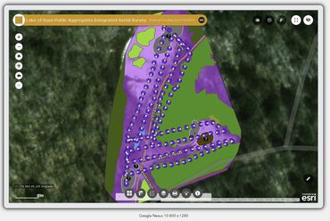
ESRI's Founder & CEO, Jack Dangermond, characterizes GIS as the precision science of location. Used to help us understand where things are and why they are there. “How” we see that data, visually, scientifically and even artistically, form our complete “understanding” of it and becomes the foundation that outlines the basis for a GIS; a Geographical Information System, “the science of where, and the technology of now”. (1)  Dangermond (ESRI), J. (2014, September 04). Jack Dangermond: GIS for Our Future. 


Using Maps, the "language of maps", your Data, and/or data we develop) we transform this information into an ESRI based Integrated Visual Location Intelligence Solution that is easy to work with and rich with live organic information

BIM (BUILDING INFORMATION MODELLING)

Building Information Modelling (BIM) forms the literal foundation of Building Sciences binding both data and visual imagery to connect, organize & optimize People, Projects, Design, Construction and provide a Management Platform to help improve decision-making and realize more predictable and profitable outcomes across all forms of A/E/C (Commercial & Residential).


We specialize in Autodesk BIM 360 Integrated Solutions.

GIS & BIM are changing the way the world works and our "understanding of the connectivity of relationships and their behaviours". The power to leverage Geographic and Facility/Building Spatial Data is available and affordable for EVERYONE. 

INTEGRATED GIS & BIM FOR THE "INTERNET OF THINGS" (IOT)

"THE INTERNET OF THINGS"

"The Internet of Things" (IOT) as it is known, refers to the collective understanding of a modern symbiotic relationship between us, the hardware we interact with, and the layers of data we use this hardware to explore (the “Web”). 

INTEGRATED GIS & BIM APPLICATIONS FOR IOT

Dynamic, Intelligent, and Data Driven Universal Desktop & Mobile Application Development for Integrated IOT propels this force forward using a languages "everyone understands" (Maps & 3D Imagery). This enable any sized business, individual, organization, regardless of industry, instantaneous access to existing/emergent/open data, communities of information, imagery, surveys, reports etc. to communicate, perform analysis, share information, and solve complex problems in "real-time" and "real-space".

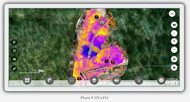
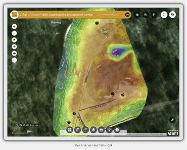
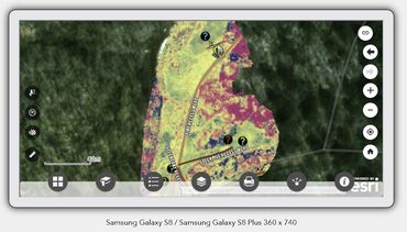
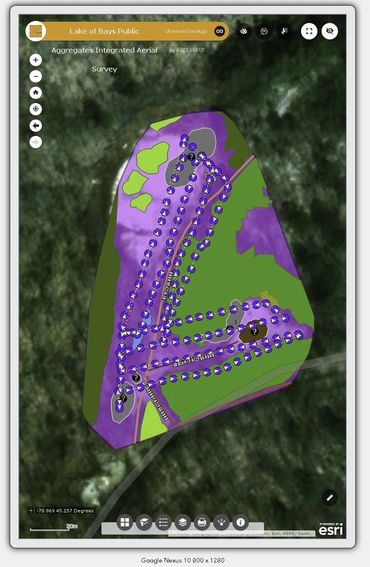
UNIVERSAL GEO-WEB APPLICATION DEVELOPMENT

ACCESSiFLY is the leading developer of Integrated GIS & BIM Solutions (Universal IOT Geo-Web & Mobile Application Deliverables), merging both GIS & BIM. Our Universal Applications are designed to remain modular so they integrate with all our Service Solutions, your data, software, CRM etc; enabling IOT Tools that function across all platforms and hardware and easily complement existing resources and those that “emerge” making them “future-proof".

Integrated DELIVERABLES –“How we do it”

ANALYSIS

UNDERSTANDING

UNDERSTANDING

Typically, the goal is to "understand the reality of Where something is (GIS)" & "how it got to that point" and/or "how to prevent it to get to that point" (BIM/RCM). 


i.e. a Data-set that looks at the movement of goods, people, and finance in relationship to multiple buildings, their assets, holds, and the building's operating structural conditions and "integrity" 


A VERY COMPLEX BUT CODEPENDENT, INTEROPERABLE AND ENTIRELY "ORGANIC" HARMONY OF EMPIRICAL DATA


UNDERSTANDING

UNDERSTANDING

UNDERSTANDING

We then outline a pathway, having understood your purposes and objectives, which we use alongside modern Project Management Training & Principles ("Waterfall", "Six Sigma", & "Kaizen") to create a plan to transform that data into a multi layered visual solution to enable fast, comprehensive and understandable Location & Asset Data Analysis. 


WE ENSURE THIS PROCESS DOES NOT BUILD A "DEPENDENCY RELATIONSHIP" OF REPETITIVE SERVICES UNLESS THAT IS A CLIENT'S WISH. OUR GOAL IS TO PROVIDE A "SOLUTION" FOR YOUR "PROBLEM" NOT TO CREATE "APP SUPPORTED" HEADACHES.


AGGREGATION

UNDERSTANDING

AGGREGATION

With a written plan in place, complete with tangible, realistic targets, measurable goals, analytics, and metrics, this process typically by taking your existing data & imagery (whatever form it may exist in), or beginning from "scratch" by working with you to collect and assemble data & imagery and information about your organization, your Facilities, Assets & Building, which for many of our clients means "Home"; using the tools and techniques you see offered in our "Services" (RPAS/"Drone", Laser Scanning/LiDAR/BIM, FLIRScan, "Big Data Aggregation" etc). 


VISUALIZATION

"INTEGRATED DELIVERABLES"

APP & DESKTOP DEV

Understanding and Visualizing the “Science of Where & How” and those multi-spatial representations of complex data is much easier to achieve using interactive layers on Dynamic 2D & 3D-Maps. We target Pragmatic Instantaneous Visualization & Analysis of Data using ESRI Powered GIS Software Solutions integrated with Autodesk BIM 360 Software.


We drive these solutions using the "Internet of Things" as a baseline vehicle which enables a Business, Organization, Agronomist, Home Owner, Government, Institution etc. to “see” their assets, liabilities, and data in a beautiful layered format at all times with the multiple levels and layers of that data interconnected and operating "live" so you can easily interpret "what you see", analyze and action on it at any one given time. 

APP & DESKTOP DEV

"INTEGRATED DELIVERABLES"

APP & DESKTOP DEV

 We take your final “GIS & BIM Data” and bundle it in a Custom Made (low cost) Dynamic Application that is deployable universally across Desktop, Web and/or Mobile Environments; enabling instant and spontaneous access to this data anywhere, at any time "offline" or "online" on any device through the Internet and/or "Internet of Things". 


Our unique Applications can easily leverage systems such as ESRI, Autodesk, RETScreen Clean Energy Manager, OFS Pro Oilfield, Lightshipworks, RockWorks, Multifreight, CEROS, MapBox, Tableau, Power Bi, Salesforce, Office 365, Adobe CMS Experience Manager, SAP, and any other existing software and/or "IOT Hardware Device", regardless of domain and/or industry (including your own "in-house" applications).


"INTEGRATED DELIVERABLES"

"INTEGRATED DELIVERABLES"

"INTEGRATED DELIVERABLES"

This process arrives in multiple file formats, with training, support and complimentary ONGOING SUPPORT for as long as a Client needs and/or wishes.


This is what an ACCESSiFLY INTEGRATED GIS & BIM SOLUTION looks like; and our service is a unique service exclusive to ACCESSiFLY.


This is the "Science of Where (GIS) & When (BIM)". 


OUR TECHNOLOGY OF "HOW".


 It is our "Patent" IP & approach, and unlike anything else (Patent #1166978).

IOT UNIVERSAL GEO WEB & DESKTOP APP GALLERY

  Contact an ACCESSiFLY Pre-sales Specialist today for further information and to begin discussing a solution to support your organization and/or individual needs. 

CONTACT US

EXCLUSIVE RESOURCES

  • TERMS AND CONDITIONS

ACCESSiFLY

57 Peterborough Avenue, Toronto, Ontario M6H 2K9, Canada

Main (647) 802-2256 Toll Free (888) 490-4205

Click HERE to access our Official Zendesk 24 Hour ACCESSiFLY Client Self Service Help & Support Center and/or Email Support Directly HERE. 

Copyright © 2023 ACCESSiFLY

COOKIE POLICY

This website uses cookies. By continuing to use this site, you accept our use of cookies as outlined in our Terms & Conditions.

DeclineACCEPT & CLOSE